
Gadgets Alert Rescuers Abroad For Nz Trampers
Gadget Alerts: Equipping NZ Trampers for Rescues Abroad
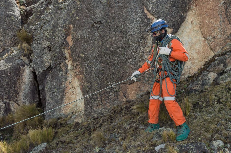
Navigating the wilderness beyond New Zealand’s familiar shores presents a unique set of challenges for trampers. While the spirit of adventure is strong, the potential for unforeseen circumstances, from minor injuries to serious emergencies, necessitates a robust approach to personal safety. Fortunately, a new generation of electronic gadgets offers unprecedented capabilities for alerting rescuers, significantly enhancing the safety net for New Zealand trampers venturing into remote international terrains. These devices are not merely novelties; they are critical tools that can bridge the gap between a solvable predicament and a life-threatening situation, particularly where traditional communication methods fail or are non-existent. Understanding the functionality, limitations, and strategic deployment of these gadgets is paramount for any serious international tramper.
The cornerstone of modern rescue alerting for trampers abroad is the Personal Locator Beacon (PLB). These compact, battery-powered devices operate on the Cospas-Sarsat satellite system, a global network designed specifically for distress signalling. When activated, a PLB transmits a unique identification signal, along with GPS coordinates, to a network of orbiting satellites. These satellites relay the distress message to a ground station, which then forwards it to the nearest Rescue Coordination Centre (RCC). Unlike mobile phones, which rely on terrestrial cellular networks that are often absent in remote wilderness, PLBs bypass these limitations entirely. For New Zealand trampers exploring backcountry in countries like Nepal, Patagonia, or the Canadian Rockies, where mobile reception is unreliable at best, a PLB is an indispensable piece of safety equipment. The crucial advantage of a PLB is its dedicated emergency function. There are no competing apps, no low battery warnings from a forgotten call, just a singular, powerful distress signal. However, it’s vital to understand that PLBs are designed for distress situations only. Accidental activation can lead to significant search and rescue costs and resources being diverted. Many jurisdictions have penalties for false alarms. Furthermore, PLBs are typically single-use in terms of their activation mechanism for a specific distress event, meaning once activated, they require professional servicing and battery replacement. Registration is also a critical step; in New Zealand, PLBs must be registered with the Rescue Coordination Centre New Zealand (RCCNZ). This registration provides vital information to rescuers, such as the owner’s emergency contacts and any relevant medical information, streamlining the response process. Without registration, a distress signal, while received, will lack the context that can expedite a rescue.
Satellite Messengers represent a more versatile, though often subscription-based, evolution of the PLB. Devices like the Garmin inReach series, SPOT devices, and the ZOLEO satellite communicator offer a range of functionalities beyond a simple SOS button. While they also connect to satellite networks (such as Iridium or Globalstar) for transmitting messages, they provide two-way communication capabilities. This means a tramper can send pre-written or custom messages to designated contacts, check in regularly, and, crucially, communicate with rescuers once a distress signal has been initiated. For NZ trampers in areas with no cellular coverage, the ability to send a text-based message stating "minor ankle injury, can self-evacuate to nearest shelter" versus "major fall, suspected fracture, need immediate extraction" can dramatically alter the scope and urgency of a rescue operation. These devices often incorporate basic weather forecasting services, and some can even track a tramper’s progress, allowing pre-defined contacts to monitor their journey. The two-way communication is a game-changer, enabling rescuers to gather critical information before deployment, such as the number of people in the party, their exact condition, and any available resources at their location. This intelligent use of rescue assets can save time and lives. However, the reliance on subscription plans, which vary based on message types and data usage, is a significant consideration for budget-conscious trampers. Ensuring the subscription is active and appropriate for the intended travel duration and communication needs is essential. Battery life on satellite messengers can be a concern, especially with frequent messaging and tracking, necessitating careful power management and potentially carrying portable solar chargers or spare power banks.
Beyond dedicated rescue devices, smartphones equipped with the right apps and a portable satellite communication solution can serve as a powerful alerting system, albeit with more caveats. While unlikely to function for voice calls or standard SMS in deep wilderness, smartphones can leverage Wi-Fi hotspots in remote lodges or villages for messaging. More importantly, when paired with a satellite communication device like an inReach Mini or a Bivy Stick, they transform into an extension of the satellite network. Apps like Garmin Messenger or dedicated third-party apps allow users to compose and send messages through the paired satellite device. This offers a more user-friendly interface for typing longer messages compared to the often-limited character input on dedicated satellite messengers. Furthermore, offline map applications are essential for navigation. Apps like Gaia GPS, Maps.me, or OsmAnd allow trampers to download detailed topographic maps of their intended region for offline use. While not directly for rescue alerting, accurate navigation and the ability to pinpoint one’s location precisely are vital pieces of information to convey to rescuers. If a tramper can accurately report their coordinates from an offline map app, it significantly aids search efforts. However, it’s critical to remember that a smartphone itself cannot send a distress signal through its built-in cellular modem in areas without coverage. The reliance on external satellite hardware or rare Wi-Fi availability makes it a secondary or supplementary alerting system. Battery life is also a major concern for smartphones, especially with continuous GPS usage and bright screens, necessitating robust power management strategies and ample portable power.
The emergence of advanced GPS watches with integrated SOS functions and satellite connectivity marks another significant advancement in personal safety for trampers. Brands like Garmin have introduced models that incorporate both everyday fitness tracking capabilities and emergency communication features. These watches can often connect to a smartphone via Bluetooth and utilize its cellular connection for standard alerts. However, their true value for international trampers lies in their standalone satellite connectivity. Similar to satellite messengers, these watches can transmit SOS signals and sometimes even basic text messages via satellite networks like the Garmin inReach service. The advantage here is convenience and integration. A tramper who already wears a GPS watch for training and navigation can have an emergency beacon seamlessly integrated into their gear. This reduces the number of separate devices to carry and manage. Functions like fall detection, which automatically trigger an SOS if an unusual impact is detected, further enhance safety, especially for solo trampers. However, these features are typically dependent on a subscription service, similar to dedicated satellite messengers. The small screen size can also limit the complexity of messages that can be sent or received. Battery life can be a concern, particularly with continuous GPS tracking and satellite communication enabled. Users must be diligent about charging and power management, especially on extended expeditions. The cost of these advanced watches can also be a significant investment.
Beyond active alerting devices, passive safety measures and emergency preparedness remain critically important. For New Zealand trampers abroad, understanding the specific rescue infrastructure and protocols of the countries they are visiting is crucial. This includes knowing the local emergency numbers, which can vary significantly. For instance, 112 is a common emergency number in Europe, while in North America, it’s 911. Having this information readily accessible, perhaps printed on a waterproof card in a wallet or saved in an offline notes app on a smartphone, can save precious time. Pre-trip planning that includes sharing detailed itineraries with trusted contacts back home is fundamental. This itinerary should include planned routes, expected return dates, and information about the chosen safety gadgets. When a tramper deviates from their plan or fails to check in, this information allows their contacts to initiate a search with relevant authorities. Emergency shelters and pre-determined rendezvous points are also vital components of a safety plan in remote areas. While not gadgets, they are critical elements that, when combined with communication devices, can ensure a successful rescue. Understanding basic first aid and carrying a comprehensive first-aid kit is also non-negotiable. In many remote international locations, professional medical assistance may be hours or even days away. The ability to manage an injury until rescue arrives can be the difference between life and death.
The legal and regulatory landscape surrounding the use of communication and distress devices internationally also warrants careful consideration. Some countries may have restrictions on the types of satellite communication devices that can be brought into or operated within their borders. For instance, certain satellite phones or two-way messengers might require specific licenses or permits. New Zealand trampers planning an expedition need to research the import and operational regulations of their destination country well in advance. Failing to do so can result in devices being confiscated, fines, or even denial of entry. Similarly, understanding how distress signals are handled by the local authorities is important. While the Cospas-Sarsat system is globally recognized, the specific protocols for activating and responding to an SOS from a PLB or satellite messenger can vary between national rescue services. Registration of PLBs with RCCNZ is a New Zealand requirement, but it’s also advisable to check if the destination country has its own registration requirements for PLBs or similar devices. Some countries may require users to register their devices with their national emergency management agencies upon arrival. This ensures that local authorities have the most up-to-date information in the event of an emergency. Furthermore, understanding the potential costs associated with rescue operations in foreign countries is crucial. While many countries have provisions for providing rescue services free of charge in genuine emergencies, some may have policies that allow for the recovery of costs from the rescued party, especially in cases of negligence or false alarms.
In conclusion, for New Zealand trampers venturing into the global wilderness, a layered approach to safety, heavily reliant on modern gadgets, is no longer optional but a fundamental requirement. Personal Locator Beacons (PLBs) offer a singular, powerful distress signal via satellite. Satellite messengers provide enhanced two-way communication capabilities, allowing for crucial information exchange with rescuers. Smartphones, when integrated with satellite communication hardware and offline mapping applications, become powerful navigational and supplementary communication tools. Advanced GPS watches offer integrated SOS functions for added convenience. However, these technological solutions are most effective when combined with thorough pre-trip planning, an understanding of local emergency protocols, robust first-aid preparedness, and an awareness of international legal and regulatory frameworks. The responsible and informed use of these gadgets empowers New Zealand trampers to explore the world with a significantly enhanced safety net, transforming potential emergencies into manageable situations and ensuring a higher likelihood of timely and effective rescue.


